Discovering the Ancient Country of the Treveri

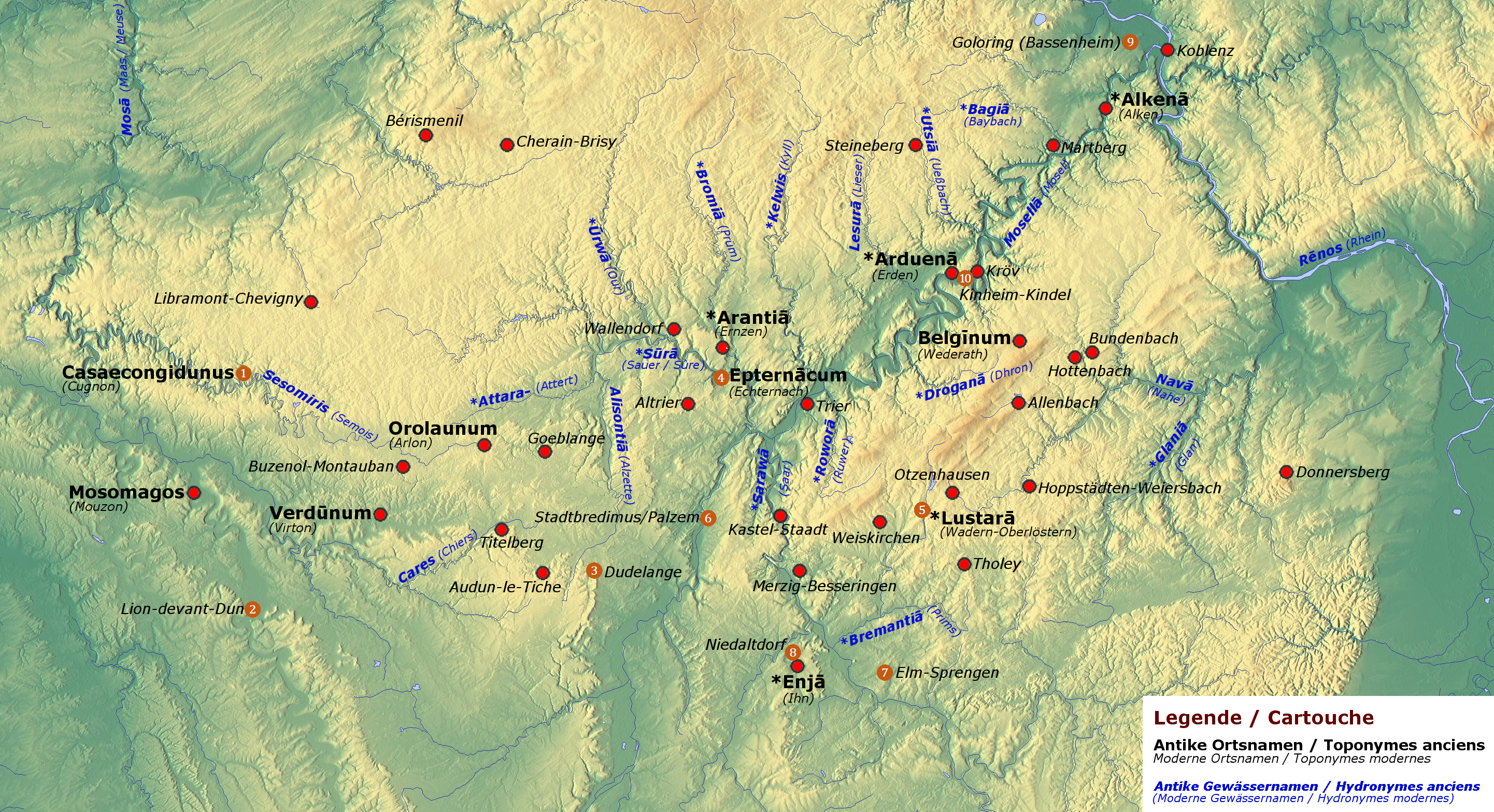
As you move the mouse over the dots and names on the map, more information about the objects will be given in pop-up windows.
Eine deutsche Version dieser Karte ist in Vorbereitung. Une version française de cette carte est en préparation.
Click to go back to the index page

Echternach Echternach
The valley of Echternach has already been inhabited in the Celtic La Tène period, during the last centuries BCE. In the first century CE, one of the largest Roman villas of the northwest provinces of the Empire was constructed there.
Another important factor for the history of the region was the imperial abbey (Reichsabtei Echternach), founded by St Willibrord in 698. Willibrord hailed from Northumbria and received his training at the Irish monastery of Rathmelsigi. He is known as the "apostle of the Frisians" and bishop of Utrecht. He died at Echternach on 7 November 739. The saint was accompanied by Irish scribes, a fact apparent from illuminated books preserved and produced at the local scriptorium. A Latin manuscript from the ninth century, kept in Paris today (BNF Paris lat. 10290), a grammar of Priscian in insular script, contains Old Irish and Old Breton glosses, which belong to the oldest of their kind.
The name Echternach goes back to Epternācum, derived from the personal name Epternos, which is known, in its Latin form Epternus, from a local inscription.

The Roman villa (Photo: David Edgar, CC-BY-SA-3.0)
The Priscian grammar (BNF Paris lat. 10290, f. 3r)
Altrier Altrier
The Celtic burial mound with a diametre of 50 m was discovered in 1972. It was constructed around 430 BCE, as dendrodates of wooden beams from the burial chamber revealed. An iron sword, a golden bracelet and a fibula, a bronce bucket and remains of the cremation were found, which are being kept in the Musée Nationale d'Histoire et d'Art de Luxembourg.
Mouzon Mouzon
The village in the French department Ardennes is situated on the western border of the Treveran territory, itself already being part of the polity of the Remi. During the Celtic period, there was a harbour and certainly a ferry service across the river Meuse. In the Roman period, the settlement was expanded to a vicus on the road from Reims to Trier (Trèves). The village probably appears on the famous road map, Tabula Peutingeriana, from the fourth century under the entry "Mosa". Approximately 3 km to the southeast of Mouzon, in the "Bois de Flavier", a Gallo-Roman sanctuary, a Fanum, was found and excavated in 1967. The foundation walls of the temple site have been preserved. The sanctuary had a Celtic predecessor as well as an earlier Roman one from the era of Augustus. A number of weapons in miniature were found on the site, which were used as offerings in the first century CE.
The name Mouzon goes back to Celtic *Moso-magos, 'Meuse field'.

(Photo source: commons.wikimedia.org, photo by Francis Neuvens, CC-BY-SA-3.0)
Belginum Archäologiepark Belginum (Archaeological Park Belginum)
The museum near Morbach shows the findings of a Roman village, the vicus Belginum, its burial ground, a Gallo-Roman temple complex and a Roman military camp.
The necropolis is particularly interesting, as its tombs date from the long period between c. 400 BCE to 400 CE.
The name Belginum derives from the personal name (and ethnonym) Belgos, which probably means 'with a swell of pride', from Proto-Indo-European *bʰelgʰ- 'swell'.
Libramont-Chevigny Bérismenil Bérismenil
On a rocky promontory above the river Ourthe, called "Le Cheslé", a large fortification of about 13 hectares has been constructed. It was in use from the fifth century BCE on (LT A and B). It has a double rampart system of more than 1.7 km length. The access was originally in the north and later on a little more to the northwest. All other sides are protected by steep slopes. There have been excavations from the 1960s on, and in 1980, part of the rampart has been reconstructed. Most probably, Le Cheslé is just outside the territory of the Treveri.

(Photo source: commons.wikimedia.org, Anabase4, CC-BY-SA-3.0)
Libramont-Chevigny, Musée des Celtes
The "Museum of the Celts" is dedicated to the the study of the Celtic culture in the Ardennes. It intends to unite numerous small collections, to add new items, especially from the research carried out by the Centre de Recherches Archéologiques en Ardenne, to preserve the findings and to present them to the public. The Museum lays particular emphasis on the correction of current stereotypes and prejudices about the Celts. Among others, it houses findings from Bérismenil, Cherain-Brisy and Cugnon.

(Photo link: Musée des Celtes)
Cugnon Cugnon
"Le Trînchi" near Cugnon is a fortification of the late Hallstatt (c. 500 BCE, Ha D) and the middle La Tène periods (c. 250 BCE, LT C). The rampart, which has been reconstructed up to a length of 50 m, is assigned to the type "Altkönig-Preist".
The place name is recorded in c. 644 as Casaecongidunus, 'in the house of Congidunus', casae being a precursor of French chez. The personal name has been compared to Brittonic Cogidubnus.

(Photo source: auby.be/cugnon)
Lion-devant-Dun Lion-devant-Dun
East of the modern village in the department Meuse, there is an elongated ridge with an oppidum of approximately 18 hectares on top of it. The southern flank is protected by a rampart, which is still up to 6 m high. In front of the wall, two ditches of c. 10 m width have been constructed. Sondages revealed pottery of the late La Tène period (1st century BCE, LT D) and of the Roman imperial period (3rd to 4th centuries CE). The name "Lion" derives from Latin Ad Leones.
Audun-le-Tiche Audun-le-Tiche
The small town near Esch-sur-Alzette in Luxemburg hosts interesting finds of the Celtic and Roman ages as well as a large cemetery of the Merovingian period. In the vicinity of a necropolis of the early Middle Ages at "Le Calvaire" in the "Bois de Butte", a Gallo-Roman temple (fanum) of the second or third century CE was found, whose foundation walls can still be seen. Nearby, a group of figures from a Jupiter column (cavalier à l'anguipède) came to light. The Jupiter columns translate an indigenous Celtic mythological motif into Roman imagery. Heads from statues, probably of Juno, and of Minerva with a helmet were also unearthed in the area. A Roman inscription from Rue de Bétiel shows a number of Celtic names, including Solitumarus, Sorina, Carantillus und Carassouna. These names, superficially adapted to the Latin language by changing the original ending -os to -us, show clearly how strong the Celtic language remained in the onomastics of the region.
The findings can be viewed at the Musée d’Archéologie et d'Histoire locale. The cemetary and the fanum belong to an archeological site (espace archéologique).
Link to the Jupiter column (photo: Société d'Archéologie et d'Histoire Locale Audunoise, SAHLA)

(Tomb in the Merovingian cemetary)
Dudelange Festival "Zeltik" in Dudelange
Each year since 1998, mostly in March, the Celtic Celebration takes place in Dudelange (Diddeleng, Düdelingen). It has developed into a major attraction far beyond the local region. Internationally renowned representatives of the "Celtic" music scene regularly appear on stage such as Carlos Núñez, Moya Brennan, Capercaillie, Beoga, Tri Yann, Red Cardell etc.

(Photo: Bagad Naoned de Nantes, 2003, CC-BY-SA 3.0)
Stadtbredimus/Palzem Stadtbredimus (L), Palzem (D)
In a construction pit, remains of oak poles from different buildung phases were excavated. Thicker posts belong to a Roman bridge built about 30 CE. Between them, thinner stakes with a diametre of approximately 20 cm and cutting dates of 168 and 149 BCE (middle La Tène period, LT C) have been found.
The name Bredimus derives from Celtic *bred-īnā '(place where) one wades' from Proto-Indo-European *bʰredʰ- 'to wade', obviously an old name of a ford.
Merzig-Besseringen Merzig-Besseringen
In the 19th century, a chariot tomb of the La Tène period was found on the hill 'Müllersknüppchen'. The tomb was equipped with a richly ornamented golden torque, bronze fragments of the chariot with ornamental fittings, an Etruscan bronze beak flagon and incinerated bone remains of a woman. Unfortunately, most burial objects are lost. The torque is still being withheld in Russia as "looted art", the chariot fittings are being kept in Rheinisches Landesmuseum Trier.
Ihn Ihn, Sudelfels
Near Wallerfangen, in the district of Ihn, there is the Gallo-Roman water sanctuary "Sudelfels", dating from approximately 150 to 250 CE. The sacred enclosure includes an octogonal well building. Findings of figurines and inscriptions indicate pilgrimages to Gallo-Roman deities such as Rosmerta and Sirona as well as to the supraregionally venerated healing god, Apollo.
The place name Ihn derives from Celtic *en-i̯ā '(spring) with cloudy water', from Proto-Indo-European *pen- 'mud, swamp', cf. Gaulish anam 'swamp' from *pn̥-.

(Photo: Roger Zenner, CC-BY-SA-2.0-DE)
Niedaltdorf Niedaltdorf
After the discovery of twelve Celtic tombs dating from the period from c. 600 to c. 200 BCE (Ha D to LT C), a Celtic farmstead, consisting of a dwelling and a storehouse, has been reconstructed from 2003 to 2006. The farmstead is part of the "Druid Way", a circular route stretching approximately 6 km on the border of France. Each year on 1 May, the Irish spring festival Bealtaine is adapted on the site.

(Link source: www.rehlingen-siersburg.de)
Elm-Sprengen Elm-Sprengen (Sauwasen)
In a stretch of the "European Celtic Route" in the forest of Herchenbach, four burial mounds were found, containing grave goods of the late Hallstatt period (5th century BCE, Ha D). One of the mounds has been reconstructed as a recognizable hillock in 2005, a wagon tomb (mound 3) in vertical section in 2007. In the wooden burial chamber, the wagon can be seen, besides a dummy of the deceased and examples of grave goods, which were not preserved at this site except for a golden earring.

Celtic Trail (Keltenwanderweg): www.schwalbach-saar.de.
Erden Erden
The "Borberg" or "Burgberg" north of Erden, on the opposite bank of the river Moselle, drops steeply towards the valley. On top of it, there is a fortification enclosing an area of about 3 hectares. It is secured by a semicircular sectional wall on its north side, a Pfostenschlitzmauer ("post-slit-wall") that was erected in two phases. Oak wood from a rectangular post structure of approximately 5 x 8 m on the highest point date from around 67 BCE. Pottery from this enclosure shows middle and late La Tène dates (LT C, c. 250 to 150 BCE and LT D, c. 150 to 15 BCE), although the first occupation may have already started in the fourth century BCE. The mountain top was shortly inhabited during the Roman period in the third century CE.
The name Erden and the first element of the river name Erdgemund both go back to *Arduena 'at the high mountain', derived from the adjective *arduo- 'high'. The copy of a document from Echternach of 774/775 reads super fluvio Muselle in monte Ardinigo "above the river Moselle on mount Ard(u)inius".

(The Borberg from the west, photo: IMercileZz, CC-BY-SA-4.0)
Kröv Kröv
The Burgberg near Kröv is a spur fortification of the Hunsrück-Eifel culture (HEK I), which was constructed around 500 BCE. On three sides, the plateau is secured by steep slopes. To the north-east, two sectional walls with narrow passages have been erected, which enclose a usable area of about 6000 square metres. In the north-west corner, the wall continues about 60 m for no apparent reason. Pottery and a socketed axe have been found on the site.
The name Kröv, known from documents of the years 747 to 751 in copies of 1222, was Crovia, from a word for 'crooked terrain, hill flank', Proto-Indo-European *krou̯- (IEW 938), cf. the French toponym Crouy. Another derivative, *krou̯ko-, 'heap, hill' is widespread in modern Celtic languages such as Irish cruach, Welsh crug.
Bundenbach Kinheim-Kindel Kinheim-Kindel
In the wine producing village on the Moselle, a representation of the Gallo-Roman god Sucellus in high relief was found in a villa complex in 1976. It measures 80 cm in height and dates to the third century CE. A copy of the effigy and the foundation walls of the villa can be seen on the spot, other architectural remains have been covered with earth to protect them. Sucellus is shown with a beard and with a mallet, grapes and barrels. He was a Celtic god, venerated as a deity of the woods and of fertility. In the Gallo-Roman period, he was primarily a divinity of viticulture.
The name Sucellus probably means "he who strikes well", from Celtic *su- 'good' and *kell-, from Proto-Indo-European *kelh₂- 'to strike'.

(Photo: Forum Celtic Studies)
Altburg near Bundenbach
The open air museum Altburg shows the reconstruction of a small Celtic fortification, as it might have looked like in the second and first centuries BCE. The building complex was excavated between 1971 and 1974 by Rheinisches Landesmuseum Trier. The second of the three building phases has been reconstructed on the site. It is part of re-enactment events such as the "Altburg Festival", with a "Celtic fair" and a music festival each year in August, see Altburgfestival (in German). For part of the year, the settlement is inhabited by modern "Celtic" enthusiasts.

(Photo: Chris mz, CC-BY-SA 3.0)
Wadern-Oberlöstern Wadern-Oberlöstern
In the vicinity of early Celtic burial mounds, two Gallo-Roman monumental tumuli dating from the second or third century CE were excavated from 1991 to 1995. These representative buildings with a diametre of 20 m were framed by square settings of sandstones and crowned by pine-cones of stone. The hill shape is untypical of the period.
The name Wadern, attested as Waderella in a document of 950 CE, derives from late Gaulish *u̯adr-ellā 'little water' and ultimately from Proto-Indo-European *u̯odr̥-, u̯edōr 'water' and the diminutive suffix *-ellā; the vowel o changes to a after the half vowel as in Gaulish and Brittonic in general. See the website of Wadern (in German)

(Photo: L. Sieht, CC-BY-SA 3.0)
Meuse River Meuse (Dutch, German: Maas)
The river Meuse rises in Pouilly-en-Bassigny in the French department Haut-Marne and flows north into Belgium and the Netherlands. It marks the western frontier of the Treveran territory at Mouzon and perhaps further to the north. After c. 874 km, it meets the Rhine-Meuse-Scheldt delta. Its nearest point to the Moselle is c. 12 km near Toul.
The names Meuse or Maas derive from Celtic *Mosā, which, in turn, is likely to be from (late) Proto-Indo-European *mud-sā 'lively, vivid (river)'. At any event, it is part of the so-called "Old European hydronymy", which predates the Celtic languages.

The Meuse near Sedan (Photo: Shift01, CC-BY-SA 3.0)
Kastel-Staadt Kastel-Staadt
The Celtic oppidum, a fortified urban settlement on the plateau above the river Saar, has an inner surface of 30 hectares. The walls are still up to c. 7 m high. The oppidum was in use from at least around 100 BCE. Settlement findungs have been made near the modern church. Potsherds and Celtic gold and silver coins are known from all over the area. In the Roman period, a theatre was constructed on one of the steeply sloping hill-sides.

Freudenburg to the south-west of Kastel-Staadt had an old name "Usme", in 1052 "Ossima", which derives from Gaulish *Uxsamā "highest (place), height".